 Experimental and/or
modeling studies to
investigate the urban boundary layer are often focused on either the exchange processes
near the surface or the flow in its upper part - but rarely both aspects are given equal
weight. B
Experimental and/or
modeling studies to
investigate the urban boundary layer are often focused on either the exchange processes
near the surface or the flow in its upper part - but rarely both aspects are given equal
weight. B
|
BUBBLE is made possible by a large number of grants and resources from many institutions:
|
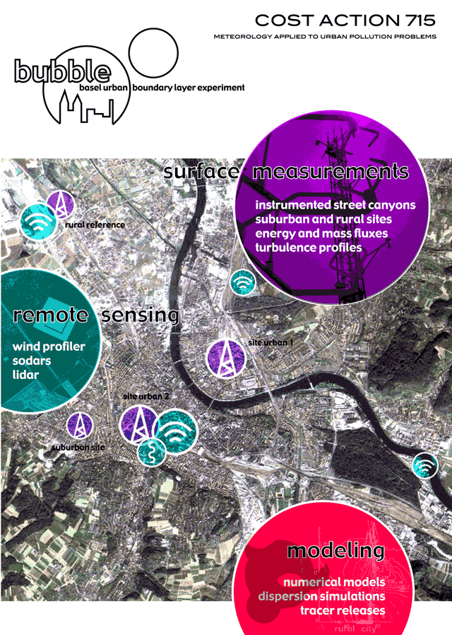
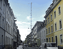 A
yearlong operation of surface and surface based remote sensing
instrumentation in the city of Basel (Switzerland) was carried out
between August 2001 and July 2002. At 'surface'-sites
the vertical structure of turbulence characteristics within the urban roughness sublayer
was observed in detail.
A
yearlong operation of surface and surface based remote sensing
instrumentation in the city of Basel (Switzerland) was carried out
between August 2001 and July 2002. At 'surface'-sites
the vertical structure of turbulence characteristics within the urban roughness sublayer
was observed in detail.
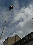
 At the same time, the flow field in the bulk of the urban
boundary layer was monitored using remote sensing techniques (wind
profiler, SODAR, RASS and LIDAR). In the Intensive Operation Period (IOP)
in June / July 2002 additional instrumentation that is more limited by the available manpower
(scintillometric measurements, tethered balloons) was deployed.
At the same time, the flow field in the bulk of the urban
boundary layer was monitored using remote sensing techniques (wind
profiler, SODAR, RASS and LIDAR). In the Intensive Operation Period (IOP)
in June / July 2002 additional instrumentation that is more limited by the available manpower
(scintillometric measurements, tethered balloons) was deployed.
 During
the IOP a series of tracer experiments were carried out. The tracer experiments yield by giving
rise to translate the results concerning the flow and turbulence structure of the urban
boundary layer into parameterisations for an urban meteorological pre-processor and fill
in a gap of missing near-surface tracer release experiments over urban areas.
During
the IOP a series of tracer experiments were carried out. The tracer experiments yield by giving
rise to translate the results concerning the flow and turbulence structure of the urban
boundary layer into parameterisations for an urban meteorological pre-processor and fill
in a gap of missing near-surface tracer release experiments over urban areas.
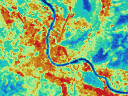 In combination with the surface data, Satellite
Remote Sensing is used to compute spatially resolved radiation and heat fluxes
in the city of Basel for selected overpasses during the IOP.
In combination with the surface data, Satellite
Remote Sensing is used to compute spatially resolved radiation and heat fluxes
in the city of Basel for selected overpasses during the IOP.
A mesoscale meteorological model is utilised complementary to the observational data. On one hand, the observational data is used to validate generalise and possibly improve some aspects of the urban turbulence and surface exchange parameterisations. On the other hand, the still limited spatial resolution of the observational data can be improved by means of the model simulations.
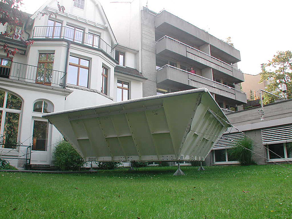
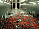 A
wind tunnel model of the central city
part "Kleinbasel" at the
scale 1:300 will provide an extensive reference data set for urban turbulence and pollutant dispersion
particularly suited for the comparison with numerical model predictions. It
is also expected to complement and help the
interpretation of the full scale measurements which have been made within
the model area at the main urban site.
A
wind tunnel model of the central city
part "Kleinbasel" at the
scale 1:300 will provide an extensive reference data set for urban turbulence and pollutant dispersion
particularly suited for the comparison with numerical model predictions. It
is also expected to complement and help the
interpretation of the full scale measurements which have been made within
the model area at the main urban site.
Over all, it can be expected that the project will help to substantially increase our knowledge on the urban wind field, the associated surface energy balance and the resulting (urban) mixing height. This knowledge can directly be translated into parameterisation for urban meteorological pre-processors for dispersion modelling and will also guide the turbulence parameterisations in NWP models when grid resolution will have dropped below urban scale.
> Instrumentation (IOP)
> Instrumentation (Full Year)
>
BUBBLE Project Press Release (28.9.2001, in
german).