Digital Terrain Model

Digital Terrain Model
|
|
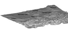
The KABA study area comprises 33km west-east and 51km north-south extention. It is
covering the two cantons of Basel, Basel-Stadt and Basel-Landschaft, but also parts of
other Swiss cantons, France and Germany. The location of Basel in a valley surrounded by
mountains of the Black Forest in the east, the Vosges in the northwest, the hilly region
of the Sundgau in the west and the Swiss Jura in the south necessitates the application of
digital elevation model (DEM).
Differences in elevation above sea level range between 250m a.s.l. in Basel up to about 1250m a.s.l. in the Swiss Jura. Several DEM with different resolutions were combined and processed, so that now a DEM with a resolution of 25m and 100m is available for the whole study area. The resulting DEM was then used for a further digital morphometric analysis procedure.
The Digital Terrain Model (DTM) consists of layers for inclination, aspect angles and other terrain parameters like depths of 'potential lakes', superelevation of full forms (relative heights of hills etc.), pathways of drainage flows, membership to drainage basins etc.. Some of the terrain parameters are due to local conditions while others had to be evaluated out of the non-local terrain conditions. All terrain parameters had been calculated by particularly designed and optimized programs. The information is calculated for each grid element with resolutions of 25 and 100m².
For further, more detailed information you may click on Proceedings, see publication list or contact Dr. Dieter Scherer or Dr. Ute Fehrenbach.