Climate Analysis Maps for Planning Aspects of Solothurn/CH
![]()
The climate analysis map and the map with planning guidelines are based on an analysis of climatic conditions in the Swiss Canton Solothurn resulting from the complex interdependencies between the natural environment and land use. The maps and digital data layers will supply planning authorities with specific climate information according to their needs. Spatially distributed data enable planners to consider interactions between ventilation conditions, air quality and thermal stress with respect to both existing and projected land-use changes.
Basic information layers include land use and ventilation situations as in the precursor project KABA (Climate Analysis of the Region of Basel/Switzerland). Data sets consist of satellite data (Landsat-5 TM, ERS-2 SAR), digital terrain models and measurement data (meteorological and air quality data). The methods developed and applied in KABA are further improved in CAMPAS.
CAMPAS is finished since the end of October 2000. It was divided into two phases: phase 1 started in February 1999, phase 2 in March 2000. To get a clue of the methodology and the results achieved in both phases, have a closer look at the corresponding links (cf. objectives). You will see examples for the digital layers serving as basic layers for the maps.
The final maps are not published in the Internet. Due to the fact that they were produced for Switzerland, the language used is German. From November 2000 to February 2001, final design and preparations for printing process are carried out at our institute financed by the Canton Solothurn. Printed maps are probably available in April 2001 at the following Cantonal authorities:
![]() Amt für Umwelt, Sektion Luftimmissionen,
Werkhofstrasse 5, CH-4509 Solothurn
Amt für Umwelt, Sektion Luftimmissionen,
Werkhofstrasse 5, CH-4509 Solothurn
![]() Amt für Raumplanung, Werkhofstrasse 59, CH-4509 Solothurn
Amt für Raumplanung, Werkhofstrasse 59, CH-4509 Solothurn
If you are only interested in a brief overview or the aspects of application of the project in german language, please click on the following link / Falls Sie nur eine kurze Projektübersicht bzw. einen Einblick in die Anwendungsaspekte des Projektes wünschen, betätigen sie bitte folgenden Link:
![]() Klimaanalyse und Planungshinweiskarten für den
Kanton Solothurn (CAMPAS/CH)
Klimaanalyse und Planungshinweiskarten für den
Kanton Solothurn (CAMPAS/CH)
![]() Objectives:
Objectives:
Phase 1: Production of a climate analysis map on the scale of 1:60.000 for the area of Canton Solothurn
Phase 2: Production of a map with planning guidelines on the above-mentioned scale
![]() Project
Organization:
Project
Organization:
| MCR Lab | Principal Investigator: | Prof. Dr. Eberhard Parlow |
| Project Coordinator: | PD Dr. Dieter Scherer | |
| Scientist: | Dr. Ute Fehrenbach | |
| Company | Involved: | Metinform GmbH, Reinach |
| European Space Agency (ESA) | Person Responsible: | Jürg Lichtenegger, Frascati, Italien |
| Amt für Umwelt | Collaborators: | Rolf Stampfli / Hansjörg Liechti |
| Amt für Raumplanung | Collaborators: | Hans Ulrich Ammon / Dr. Horst Düster |
![]() Study Site:
Study Site:
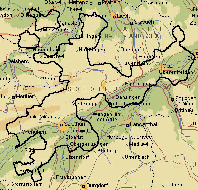 |
Spatial extention of the study site: 590'000 - 645'000 m ~ 55 km W - E 210'000 - 265'000 m ~ 55 km N - S Canton Solothurn is marked with black line. |
![]() Time Schedule:
Time Schedule:
Project start: February, 1999 ![]() - Project end: October,
2000
- Project end: October,
2000
![]() Funding:
Funding: 
This project was funded by European Space Agency (ESA) as part of the Data User Programme (DUP).
Final map design and printing is financed by the following Cantonal authorities of Solothurn: Amt für Umwelt (AfU) and Amt für Raumplanung (ARP).
![]()
![]()
![]()